
VIP member

Huace GPS-X7 RTK measuring instrument
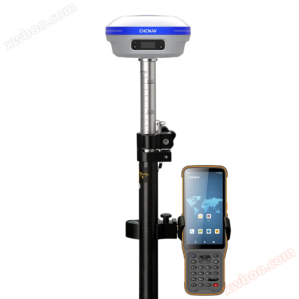
Introduction - Introduction X7 RTK Huace Navigation X7 RTK is a revolutionary RTK product that integrates the latest AI technology.
Product details
1IntroductionBrief introduction

X7 RTK
Huace NavigationX7 RTKIt integrates the latest technologyAIA revolutionary technologyRTKProduct.X7 RTKAdopting the third-generation satellite antenna, the efficiency of searching and locking satellites has been improved30%Fully compatible with five-star and sixteen frequency points. Not only is the signal strong, but the battery life is also long-lasting. It adopts the latest power management system, and the typical mobile station has a battery life of up to18Hour. Combining the latestAItechnologyX7 RTKIt can achieve speed and efficiency improvement throughout the entire stage of road construction,AIThe service of automatically compiling road data, to the layout of all road elements, allows users to bid farewell to the tedious and time-consuming engineering problems of compiling data.
IIfeatureProduct features


IIIParametersParameter
| project | content | indicator |
|---|---|---|
|
Satellite and Accuracy ① |
|
|
|
Satellite system |
GPS+BDS+Glonass+Galileo+QZSS, Support Beidou 3rd generation, support 5-star 16 frequency |
|
|
Initialize reliability |
99.9% |
|
|
Static accuracy |
Plane accuracy: ± 2.5mm+0.5 x operating distance x 10-6mm Elevation accuracy: ± 5mm+0.5 x operating distance x 10-6mm |
|
|
RTK精度 |
Plane accuracy: ± 8mm+1 x operating distance x 10-6mm Elevation accuracy: ± 15mm+1 x operating distance x 10-6mm |
|
|
GNSS+Inertial Navigation ② |
IMU update rate |
200Hz |
|
tilt angle |
0~60° |
|
|
Tilt compensation accuracy |
10 mm+0.7 mm/° tilt (accuracy within 30 °<2.5cm>2.5cm) |
|
|
user interaction |
LCD screen |
A quasi retinal screen that can be seen clearly and transparently even under direct sunlight |
|
indicator light |
1 satellite light+1 differential data light |
|
|
button |
Fn function key+power/confirm key |
|
|
Web page |
Support PC/mobile web pages |
|
|
speech, voice |
Support voice broadcasting |
|
|
physical properties |
size |
Φ152 mm*78 mm |
|
material |
magnesium alloy |
|
|
weight |
1.25kg |
|
|
Operating Temperature |
-45℃~+75℃ |
|
|
Storage temperature |
-55℃~+85℃ |
|
|
waterproof breathable membrane |
Prevent water vapor from entering the interior of the equipment in harsh environments such as direct sunlight and sudden heavy rain |
|
|
Waterproof and dustproof |
IP68 (resistant to immersion in 1 meter of water for 30 minutes) |
|
|
impact resistance |
IK08 (withstand mechanical impact equivalent to a 2.5-kilogram steel hammer without damage, and withstand a 3-meter drop) |
|
|
Electrical performance |
battery |
Typical 18 hour battery life for mobile stations |
|
fast charging |
Support fast charging, up to 15W fast charging |
|
|
External power supply |
(9-28)V DC |
|
|
store |
8GB |
|
|
Electronic bubble |
support |
|
|
wireless communication |
wireless connection |
Support Wi Fi data link |
|
radio station |
Built in transceiver, supports up to 2w transmission power, supports Huace/TT450/transparent transmission protocol |
|
|
Control Handbook |
model |
HCE600 Android Measurement Notebook |
|
operating system |
Android 10 |
|
|
CPU |
Eight core 2.0GHz processor |
|
|
network |
4G full network, built-in eSIM, and three years of surveying and mapping data free |
|
|
LCD screen |
5.5 '' High Definition Display Screen |
|
|
battery |
14 hour battery life |
|
|
Waterproof and dustproof |
IP68 |
|
|
Advanced features |
intelligent function |
Supports super dual sending, super dual receiving, and one click fixation |
|
Smart Service |
Support Huace Cloud Services, provide cloud storage, share function codes, and offer intelligent road data editing capabilities |
Our company's product technical parameters and configurations are subject to change without prior notice.
Note:
① Accuracy and reliability may be affected by external conditions such as multipath, obstacles, satellite geometry, and atmospheric conditions. It is recommended to install the instrument in an open, non electromagnetic interference, and multipath environment. When the baseline is longer than 30 kilometers, precise ephemeris is required, which may take up to 24 hours of observation time to achieve high-precision static specifications.
② Strong vibrations and rapid rotation may affect the accuracy of inertial navigation.

4accessoriesParts


Online inquiry
-
Contacts
-
Company
-
Telephone
-
Email
-
WeChat
-
Verification Code
-
Message Content
-